This is the second post in our series: “Improving your forward vision” (please see the first post here). We have created SMART4D to allow you to dynamically and confidently geosteer toward the target. Our geosteering product provides a true 3D model approach and uses geophysical, geological and drilling data to geosteer with.
In this article we will discuss the importance of using the 3D model approach.
The True 3D Model Approach
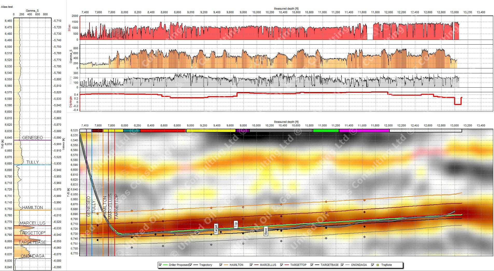
Modeling geology in 3D for geosteering in tandem with optimized waypoints, designed to remain in the sweet spot of drilling targets has proven to improve geosteering results. It minimizes doglegs, tortuosity and can have a large influence not only on the completion of the well but the drilling safety and economics of drilling.
SMART4D continuously provides updated 3D models that re-integrate all geological and geophysical (G&G) data while-drilling. This provides the proactivity needed, when combined and influenced by incoming drilling data (such as gamma). This new data is transmitted through automation of rig data, using WITSML. By automatically importing and analyzing new gamma logs and surveys, interpretations can be instantaneous and are fully included into the 3D model.
Geophysics Input
XYZ structure points from 2D and 3D seismic as well as incorporation of seismic profiles can be easily included in map views and SMART4D Panels.
The mathematical geo-statistical engine used in SMART4D is 3D Kriging. It has been automated to produce a solid model interpretation of rock properties such as gamma, porosity and resistivity besides mapping of related structural surfaces, isopachs/formation thicknesses, enabling a monitoring of spatial data and geo-hazards such as potential faults and contacts with hard layers that can destroy bits rapidly.
Current 3D Geostat Models and Their Usage in Geosteering
There are several well known full-fledged 3D models in use by geoscience professionals. They are all bulky, and have a steep learning curve. Although the larger integrated 3D models are used as a pre-drill well planning process, they are not typically used for geosteering due to complexity and difficulty to update frequently while-drilling.
It is our experience that in these environments the project geologists typically pass on the offset data and plans to operations geologists that in turn uses 2D geosteering products using the TST method. SMART4D Geosteering by contrast is a highly interactive 3D-model-based geosteering process that continually uses all offsets to build/re-build a model easily. Within SMART4D, at any point of a drilling or field development the model is always up to date and does not require reintegration of geosteering interpretations and analysis.
Modelling Philosophy
The philosophy behind all processes in SMART4D are that they have to be simple and repeatable. The driving analogy is that most people who like to drive are not interested in how the piston moves in the engine. The idea that every geoscience professional (geologists and geophysicists) should be able to build and update these 3D models with great ease.
3D Kriging was selected as one of the best 3D interpolation algorithms that considers all of the distance weighted datasets available in a project area. In SMART4D we have reduced the 3D model initializations and collapsed update times to about 5 minutes by automating the rebuilding of a geo-model down to a single command. The Learning Model may also support another well or over 100 new wells. The setup for new drills is within minutes.
Geosteering and Geomodeling
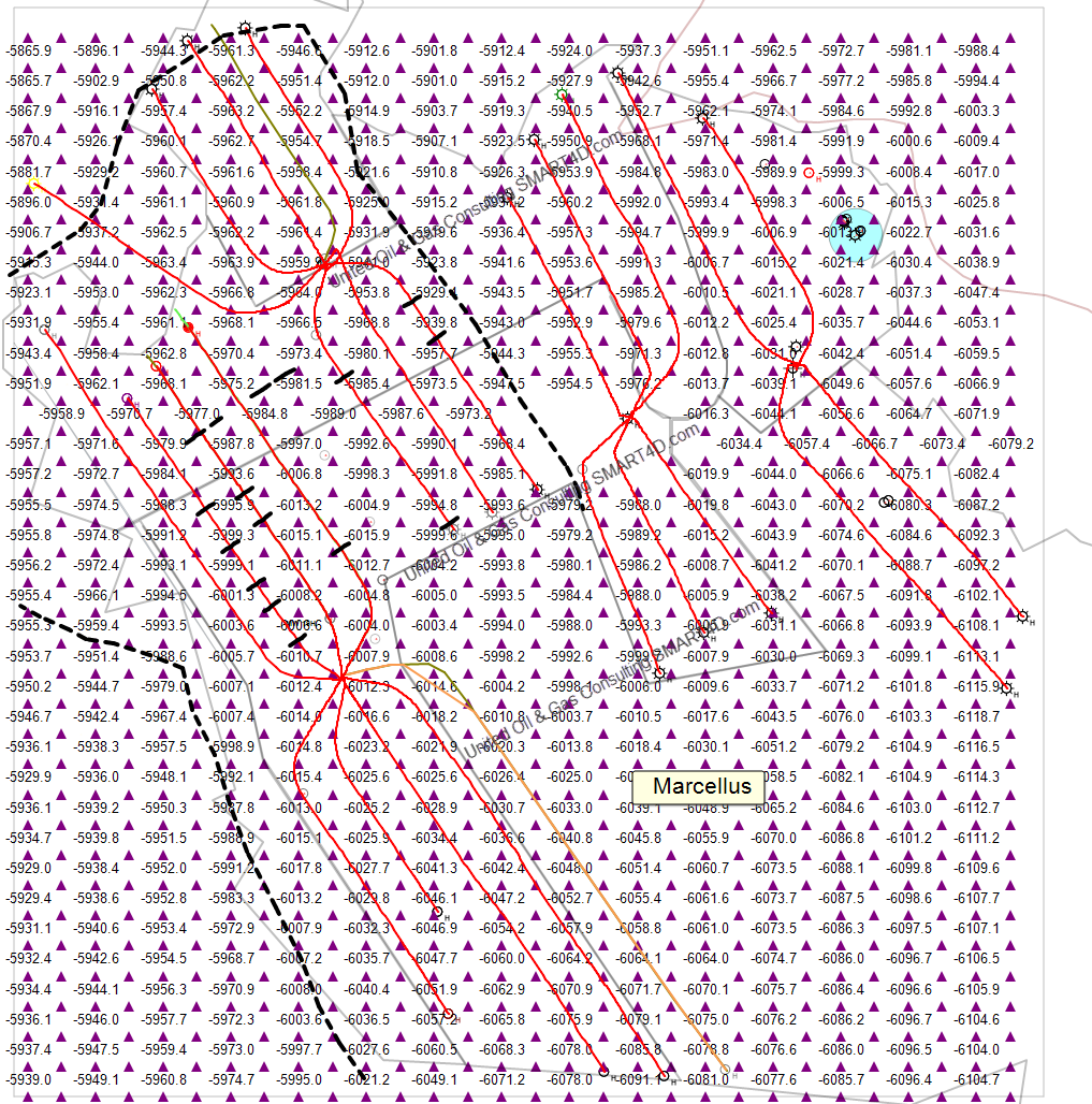
At UNITED we have had projects with more than one active rig drilling in different pads but in the same model areas updating each other’s structures and 3D Gamma properties in their path ahead of the surveys. The process improves drilling, with better waypoints, and formation accuracy. The wells remain in their engineered sweet spots longer, thus improving well completions. We are proud that our product is able to provide such great results for our clients.