SMART4D Geosteering
Geosteering Software
SMART4D is a top performing geosteering software, that uses 3D models and cutting-edge features to improve your wells.
Geosteering is the process of adjusting well placement while-drilling to improve overall well performance. Using the features of our Geosteering Software we have proven the ability to reduce drilling time, reduce dog-leg severity and increase well length in zone.
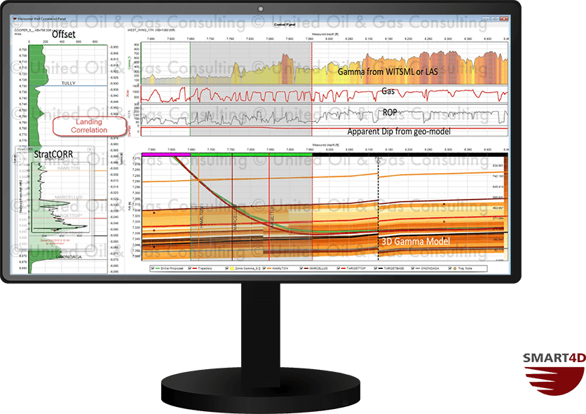
StratCORR Features
Below are some of the key parts of the StratCORR feature
- Interpret live data and correlate with offset wells
- Calculate apparent dip, adjust structures & isopachs
- Recall saved correlations for reinterpretation & information retention
- Gauge if correlations are reasonable representations of the 3D model
- Multiple offset reference wells can be used for a single horizontal
Dynamic Profile Features
Below are some of the key parts of the Dynamic Profile
- A vertical cut through the property (gamma, porosity, etc) model along the well path
- Measures the distance between survey and modelled surfaces
- Displays the position of plans and actual surveys within the model
- Predicts the expected property values (ex. API gamma) at any given point along the path

Target Planner Features
Below are some of the key parts of the Target Planner
- Dynamically design way-points within the SMART4D Panels
- Displays the proposed dogleg severity based on the way-point position
- Custom dogleg severity windows can be created by users
- Creates achievable targets for driller’s
- Reduces overall DLS and tortuosity
Additional Features
Model Dip Prognosis
- Automated calculation of the apparent dip of the target formation
- Updated apparent dip along trajectory and ahead of the bit
SMART Well Viewer
- Monitor multiple horizontal wells
- Ideal for team members interested in viewing wells without impacting interpretations
Web-based Reporting
- Allows users outside of the database setting to view the wells position
- Ability to upload drill plans, 3D models, maps, or any other files of importance to one location
- Connect to WITSML
Azimuthal and Synthetic Wellbore Imaging
- Live wellbore imaging using azimuthal gamma and resistivity tools to calculate dip
- Create synthetic wellbore image of 3D property models
Seismic Image
- Georeferencing of seismic image along well path
- Assists with well planning & geosteering within target zone
Auto-Email Reporting
- Auto-generated emails sent to custom distribution lists
- Emails populated with user choice of data and snapshot of well profiles
- Allows users to send any important files or messages to distribution list