Geosteering
What is Geosteering with United Oil & Gas Consulting?
United’s geosteering services are designed to increase the well placement in the target zone. We use our proprietary software SMART4D to ensure that this is possible.
Our geosteering services assist producers optimize their horizontal well placement and future drilling. Oriented towards operations geologists the geosteering services increase team collaboration, rapid decision-making and optimized well placement.
The geosteering services create an intelligent workflow, using real-time data integration and proactive 3D re-mappings to reduce drilling issues. This allows us to better anticipate the drilling corridor ahead of the bit for better sweet spot well placement.
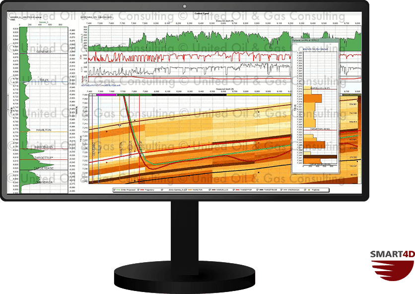
With service levels tailored to needs of our clients and the complexity of the reservoir, United is able to offer you the service solution you need. Here is a sample of what we deliver:
- Characterization modelling while-drilling in 3D (gamma, azimuthal gamma and resistivity)
- Automated data retrieval through WITSML
- Global experience
- 24/7 support
- Proactive way point recommendations
- Web-based reporting for team viewing
- 3D geo-model adjustments
- Real-time imaging
- Immersive 3D views
- Interactive SMART4D Panels
- Collision avoidance features
Live Data connectivity
Using SMART4D United’s geosteering service gathers real-time and while-drilling rig data. This reporting of live data is available automatically through WITSML. The service that we provide to our clients is compatible with all major WITSML providers, including:
- Pason US and Canada
- National Oilwell Varco (NOV)
- Petrolink
- SDI RigGRID
- Baker Hughes WellLink
- Intellifield
- Schlumberger
What do you see in realtime?
Our geosteering service includes automated gathering and reporting of live data. Our web enabled tools keep all stakeholders informed within minutes of model changes. The horizontal profiles and panels are customized for every job and include:
- Apparent dip calculations
- ROP and Gas shows
- Radial Gamma
- Near-bit Azimuthal Gamma & Imaging
- DLS & Inclination
Contact us to learn more about our services and how we can help you improve your well placement. To learn more about our services and the success-rate of the service, we have prepared a geosteering case study.
Learn more about what we do
We are happy to provide online or in-person demos either of the Geomodelling Software or of the Reservoir Engineering & Geosteering Services we provide. Please fill out the form below to get in touch with us.